

West central Illinois and the rest of the state has experienced abnormally dry conditions over the past month or so despite some slight rain yesterday evening.
It’s been so dry that a number of area farmers have concerns about the condition of their corn and soybean crops as harvest quickly approaches.

Illinois State Climatologist Jim Angel explains that certain parts of the state are experiencing moderate droughts.
“If you look at the central part of the state there is a band of what they call moderate drought, basically from the Illinois River eastward. But really, there’s some other areas, probably on the west side too that are also showing some of the same effects. We’ve had some long-term dryness throughout that area, and every once in a while we get some rain that looks like we’re going to turn the corner, but then it reverts back to dry weather. That’s certainly been the case in August and now September is that we just haven’t see that much precipitation,” says Angel.
In terms of the area agriculture, Angel breaks down some of the bigger problems these dry conditions create for local farmers.
“The downside is that, anybody that’s interested in doing winter wheat or cover crops, it’s going to be very hard to get those established when it’s this dry. Of course the dry weather already has had impacts on yields, but we can’t recover from that, the growing season is pretty much done, so any dryness early on can’t be remedied by any wet weather right now. Maybe in the short term, probably people are thinking more than, ‘if it’s going to stay dry, let’s do it for a couple more week, and then turn wet,'” Angel explains.
The lack of precipitation locally has prompted the Morgan County Farm Service Agency to inquire about precipitation totals over the past four months to determine whether the county qualifies for contract acreage through the Emergency Haying and Grazing of Conservation Reserve program through the USDA.
Possible qualification for this program is determined by whether or not there was a 40 percent loss or greater in normal precipitation amounts over that four-month period.
As for when conditions could change courses, Angel says recently high temperatures and humidity might bring more chances for rain.
“If you look at the forecast, still on one side they’re showing this continued warming for about the next two weeks, but they do show us being in a wetter pattern. We’ll see if that pans out, but it does seem like we’re in a more active weather pattern than we were in the last couple weeks. We were in this sort of cool, dry situation, now it’s getting warmer and the humidity is climbing again so it feels more like August than September. So all of that humidity give us more chance for rainfall,” Angel says.
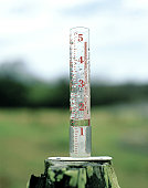
Here at WLDS/WEAI, our rain gauges recorded just 1.65 inches of precipitation in the month of August, and so far in September. Prior to yesterday’s precipitation, we had experienced only two-hunredths of an inch in September. However, that number has since risen to just under two-tenths of an inch.