

April showers bring May flowers is typically the case, but at least during the early part of May, west central Illinois is experiencing possibly severe thunderstorms.
Just as the weather around the four-county area started feeling more like a true spring, another storm system appears to be moving in from out of the Plains, bringing the threat of strong to severe storms across the central part of the state as we enter the day.

According to our news partners at WICS Newschannel 20 and meteorologist Thomas Patrick, temperatures yesterday and into today look to be unseasonably muggy and warm as a result of gusting winds from south to southwest. These warmer, muggier temps create an increased chance for storms to move into central and west central Illinois throughout the day today and potentially into tomorrow morning.
Based on the forecast, Patrick predicts the threat of severe storms could develop in two separate waves today, one of which started overnight and that we’re currently feeling the aftermath of. The second wave of potentially severe storms could develop this afternoon and into the evening. According to Patrick, the biggest actual threat posed by these potential storms comes with the possibility of extremely high winds…ones that he says could reach 60 miles per hour or stronger. There’s also the possibility of some hail, as well as an isolated tornado, though it does not seem as likely.
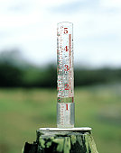
Certain communities around west central Illinois could and did experience rather heavy precipitation. Here at WLDS/WEAI we received right around six-tenths of an inch of rain, while other places in central Illinois likely experienced between one and two inches.
Friday morning is when local residents can expect to see the skies start to clear. Humidity is also likely to drop rather significantly tomorrow, as temperatures show highs in the mid to upper 70s.