

An already-water-logged West Central Illinois is getting hit with more wet weather on Monday.
We’ve measured about three-and-a-half inches of rain at the WLDS-WEAI recording station since the start of the weekend rain, and in some parts of the listening area, it’s been even heavier.

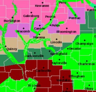
Greene County has been under a Flash Wood Warning for most of the weekend, and it’s set to expire at 2 p.m. this afternoon. That county, along with the rest of the St. Louis metro area, has seen five to ten inches of rain since Saturday morning, with up to three more inches predicted to fall today.
Phil McCarty is the Morgan County Emergency Services Coordinator.
“The biggest trouble that we’re having right now is the flash flooding. All the roadways have some water on them, whether they’re low-lying or not. Everybody needs to slow down, not to be in any big hurry, and stay out of the water that’s across the roads,” he says.
“There’s water across a lot of rural roads, across parts of lots of highways, making travel really dangerous.”
Currently there is one road closure; that’s Route 104 in Morgan County in the Rees Curve area. Regionally, it’s worth noting there’s a portion of Interstate 70 in the St. Louis area also closed due to flooding.
According to the National Weather Service, the Illinois River at Meredosia is expected to go back to major flood stage by Friday morning. It’s currently predicted to crest at 25.2 feet, about a foot above the beginning of the stage.
McCarty says there currently aren’t any plans to install sandbags.
“We’re going to wait and see what this precipitation does today to us, the amount of precipitation we receive and the amount of precipitation that they receive north of us will dictate our actions this week,” says McCarty. “We’re not going to jump to sandbagging in the freezing cold weather yet, but if we have to, that’s what we’re going to do.”
In addition, the Sangamon River near Chandlerville is expected to be near major flood stage before the end of the week.
Chuck Schaffer with the National Weather Service office in Lincoln says this is not normal weather for West Central Illinois this time of year.
“Usually, this is a little bit drier time of the year. This is more of a springtime weather pattern we’ve been seeing for much of this month, it’s more like things we’d expect in March, April or May,” says Schaffer.
Schaffer says a cooler and drier weather trend is coming up following this weather system either late this week or early next. He doesn’t believe freezing rain is going to be an issue.