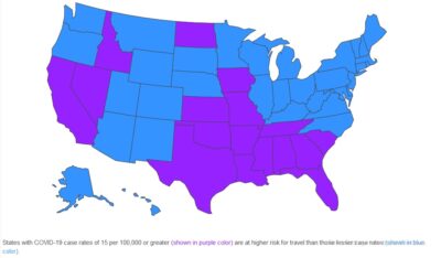
The Illinois Department of Public Health has made a guide to help assess travel risks for those who wish to travel out of the state or out of the country.
IDPH Director Dr. Ngozi Ezike says it provides a clear cut way to tell which places pose the most risk: “We know that people may have to travel, but potentially based on where you may go, that travel may increase your risk of exposure to COVID-19 by putting you in contact with people who have a higher chance of having the virus. If you have the opportunity to be taking a vacation or are able to get a couple of days away and you have some choice in the matter, please take a look at this map. It is some simple guidance. Maybe it will help you make a choice to pick one location over another.”
Ezike says that public transportation, airports, as well as bus and train stations pose great risk for transmission of the virus. The guide also includes tips for protecting yourself during each mode of travel. It’s available on dph.illinois.gov.


