

The Army Corps of Engineers, Rock Island District is giving organizations and residents along the Illinois and Mississippi Rivers a new tool to to provide better mitigation strategies and more consistent flood risk management.
The new standardized hydraulic model, which was developed using the Hydrologic Engineering Center’s River Analysis System, allow communities within the Upper Mississippi River System to evaluate flood risks and explore mitigation strategies to more effectively provide protection for those living and working in these areas.

Paul St. Louis, project manager for the Rock Island District of the Army Corps says the model allows for better planning in flood plains: “The hydraulic model is a computer-simulated model of specific flows that go up and down the Illinois & Mississippi Rivers. What it allows us to do is take a specific flood event, run it through the model, and then it will show us where the water would go. Why it’s needed is because people that work within flood plains and there’s industry in flood plains, so when those people plan activities, they want to know what they might do and how it will affect the flood plain and the river itself.”
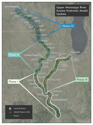
St. Louis says the model is the first of its kind for the Upper Mississippi River system. Development took place in four stages that began in 2018 and was recently completed.
St. Louis says the model is now available for public use: “The model is available to anybody who wants it for whatever purpose they believe they need it for. We’ve had universities requesting it for information for studies. The Corps has used it when we want to look at how changes in the rivers might affect one of our ongoing studies or projects. Other A.E.’s and agencies may use it to evaluate alternative designs, as well.”
Total cost of the federally funded project was $1.69 million and covers more than 1,100 river miles. For more information on the hydraulic model update or to request a copy of the model visit the Army Corps of Engineers Flood Risk Management website or contact the Rock Island District at 309-794-5729.