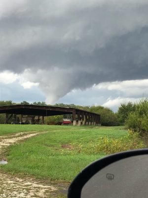
Severe weather across the region yesterday afternoon produced a handful of confirmed tornado touchdowns.
According to the National Weather Service in Lincoln at approximately 2:50PM, a tornado was confirmed by weather spotters near Athensville in northeastern Greene County, approximately 9 miles northeast of White Hall, moving north at 35 miles per hour. Severe damage is being reported out of Wrights Township with at least one large building being leveled in the area. We have not received any reports of injuries at this time.

Approximately ten minutes later, tornadoes were reported on the ground near Murrayville and Woodson, with reports of hail and flying debris near the Illinois Route 267 overpass.
At approximately 3:33, spotters confirmed a tornado on the ground just northeast of Alexander moving northeast towards Ashland and southwestern Menard County.
There were also brief funnel cloud touchdowns outside of Waverly and near Franklin.
At least one crash was reported due to the storm. A semi truck rollover with injuries and extrication was needed at approximately 3:38PM near mile markers 73 and 74 westbound near the Sangamon-Morgan County line. More information about the crash has not been released. Traffic was shut down for eastbound traffic on I-72 for an extended time after the crash so crews could clear the truck from the center median.
Morgan County ESDA Coordinator Phil McCarty says overall Morgan County was fortunate: “I think most of the impact, short of the semi [roll over] on I-72 in the general vicinity of the Sangamon-Morgan County lines, we fared very well with the impact to the rural environment. There has been no damage reported to my office as of last night, short of that accident. I do believe that ended up being in Sangamon County.”
Illinois Route 104 was closed from west of I-55 to Purdhom Road in Sangamon County due to low hanging power lines for an extended time. Traffic was diverted off the highway for several hours while Ameren-Illinois made repairs.
The National Weather Service will likely take several days before they assign an intensity level to the storm that had multiple touchdowns as it moved East. More thunderstorms are expected by Wednesday afternoon, but those storms are not expected to be severe.


